
Strategic Planning
Site Design
Site designs are bio-engineered plans which are specific to a section of a river system and carried out by an engineer. For example, site M-40 is 300 meters long; a site design on M-40 would outline the actual cost to rehabilitate this site with the landowners input. If the landowner requires a cattle crossing for rotational grazing, the estimated cost of the enhancement strategy and actual cost of the site design may be slightly different.
Enhancement strategy
An enhancement strategy is a general planned approach to rehabilitation carried out by an engineer, separate from the class environmental assessment. It outlines an estimated cost breakdown, materials needed and bio-engineering techniques needed to rehabilitate an entire river system. It also breaks down the specific sites on a river that need rehabilitated from low to high priority.
As of 2012, Manitoulin Streams has conducted enhancement strategies on the Blue Jay Creek, Manitou River, Kagawong River, Grimesthorpe Creek and the Mindemoya River. It should be noted that not all stream systems require an enhancement strategy, it depends on the complexity of the rehabilitation work that needs to be performed.
As of 2012, Manitoulin Streams has conducted enhancement strategies on the Blue Jay Creek, Manitou River, Kagawong River, Grimesthorpe Creek and the Mindemoya River. It should be noted that not all stream systems require an enhancement strategy, it depends on the complexity of the rehabilitation work that needs to be performed.
class environmental assessment
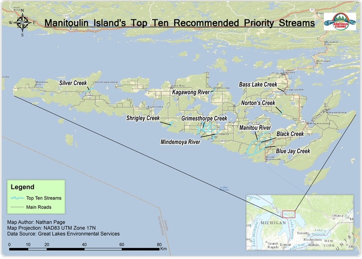
Manitoulin Streams had a Class Environmental Assessment approved in 2008 for an astounding 184 waterways on Manitoulin Island. In 2014 our Environmental Assessment went through an MNR 5-year review process and was approved. Of that 184, a top ten best-bet-list for restoration was created in no particular order. Those streams are: Manitou River, Blue Jay Creek, Black Creek, Bass Lake Creek, Norton’s Creek, Mindemoya River, Grimesthorpe Creek, Kagawong River, Silver Creek and Shrigley Creek.
The purpose of the Class EA is to provide efficient and effective project screening and evaluation, and consultation processes that are appropriately matched to projects within the class to ensure that the Ministry of Natural Resources (MNR) and its partners take into account the potential environmental effects of proposed projects within the class. For more on Class Environmental Assessments go to http: //www.mnr.gov.on.ca/245471.pdf
The purpose of the Class EA is to provide efficient and effective project screening and evaluation, and consultation processes that are appropriately matched to projects within the class to ensure that the Ministry of Natural Resources (MNR) and its partners take into account the potential environmental effects of proposed projects within the class. For more on Class Environmental Assessments go to http: //www.mnr.gov.on.ca/245471.pdf
Rosgen stream classification system
Classification systems are used to organize entities into sets on the basis of their similarities or relationships. The main purpose of classifying is to minimize variation by recognizing definable groups with similarities, and increase one’s knowledge about a member of such a group by observing the patterns characteristic of the group in general. Often, environmental classifications are based on measurable attributes of physical structure or pattern. Structure, in turn, is usually the result of physical processes and thus structurally-based classification categories are often related to natural processes or functions. Management decisions, as a rule, need to consider and be based on these natural processes or functions to be effective.
The reason for classifying streams on the basis of channel morphology, or form, is to aid the understanding of stream condition and potential behaviour under the influence of different types of changes. Specific objectives of the Rosgen stream classification include:
The reason for classifying streams on the basis of channel morphology, or form, is to aid the understanding of stream condition and potential behaviour under the influence of different types of changes. Specific objectives of the Rosgen stream classification include:
- Predict a river’s behaviour from its appearance;
- Develop specific hydraulic and sediment relationships for a given stream type and its state;
- Provide a mechanism to extrapolate site-specific data to stream reaches having similar characteristics; and
- Provide a consistent frame of reference for communicating stream morphology and condition among a variety of disciplines
Stream Locations
Pictured below is a general overview map highlighting the location of the top ten priority streams in need of restoration efforts, as identified by the Environmental Class Assessment carried out by the Ministry of Natural Resources.
For a more interactive look at the streams which have been identified for restoration, take a look at the map application below, which also contains some background information on each of the streams.
*At any point in time you can navigate elsewhere within the map as it is an active, interactive map application.
*At any point in time you can navigate elsewhere within the map as it is an active, interactive map application.
The map application below displays the locations of 5 streams which have had restoration work done as a result of local community leaders initiating partnerships with Manitoulin Streams to better their local natural environment & habitats.
*At any point in time you can navigate elsewhere within the map as it is an active, interactive map application.
*At any point in time you can navigate elsewhere within the map as it is an active, interactive map application.
