
2007 Projects
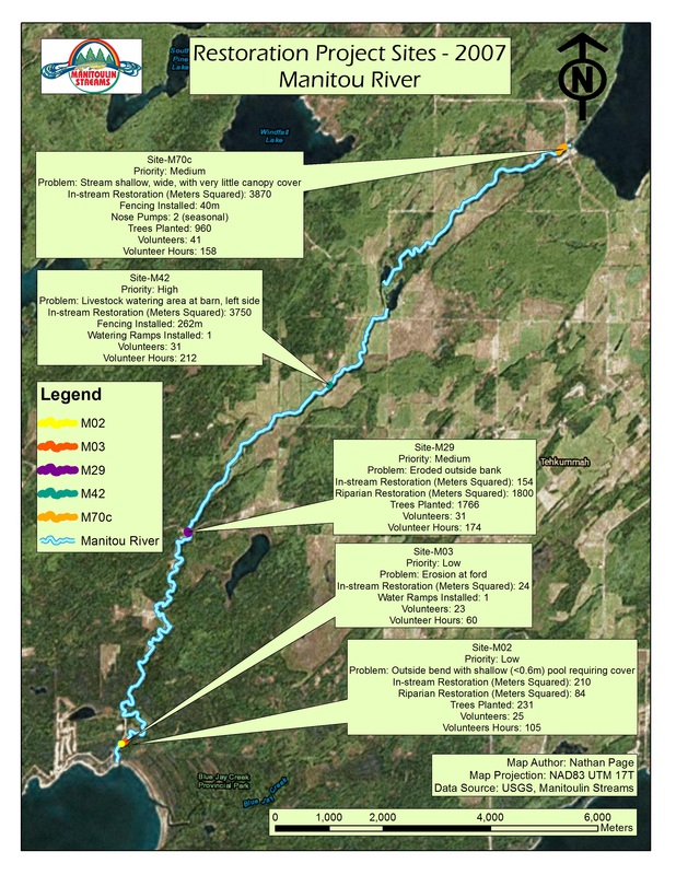
Site m02
Bank Stabilization Project
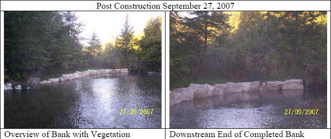
An extra 3m of boulders was installed at the corner bend to stabilize the bank and reduce the amount of erosion occurring at this site.
Manitoulin Streams-Blue Jay Creek & Manitou River Enhancement Strategy, a large scale initiative to rehabilitate the aquatic habitat of these streams. Assessment, engineering & site design was conducted to improve and protect fish habitat features in the lower reaches of the Manitou River. Improvements needed to be implemented on Site M-02 as identified in the strategy. Documented stream bank erosion was evident by the meander cutting into the unprotected bank. The significant erosion was subsequently infilling downstream pools and covering high quality spawning substrates with sediment, thus reducing the total available critical fish habitat features. Therefore, the objective was to repair erosion at the outside bend and create cover for a shallow pool (<0.6m) at this site and downstream spawning substrate. Large boulders were placed along the corner bend to add support and reduce erosion from occurring. The boulders also provide habitat for juvenile fish and aquatic invertebrates to use. Along these boulders placement of clean, smooth ½” average diameter, glacial origin spawning gravel to a depth of 0.3 m was placed over an area of approx. 200 m2.
This project had up to 19 volunteers from Manitoulin Streams working on this project at various times. A total of 60 volunteered hours was dedicated by “Manitoulin Streams” committee members attending meetings to discuss planning procedures. Manitoulin Streams had numerous meetings and email communications to discuss the details about this project including sending out Site Design Request for Proposals, Tenders, and Site Supervision to ensure proper delivery of site design and issuing a winner of the bids. Overseas communication (by phone and email) with the landowners had to take place in order to rehabilitate this site. Also, meetings with employees of the Royal Michael’s Bay Resort on behalf of the landowners to gain access to the property for site rehabilitation took place. A Grade 12 student from Germany volunteered 30 hours to conduct invertebrate sampling at various sites along the Manitou River to gain baseline information about the diversity of invertebrates before rehabilitation efforts take place. Future studies at this site will determine if there is an improvement as a result of the rehabilitation of M2. The Lake Manitou Area Association volunteered 5 people to transplant 231 trees and shrubs once the boulders were installed. These trees will provide shade/cover as well as leaves and debris that will increase habitat and provide a food source for the beginning of the food chain (i.e. invertebrates, fish). A total of 21m of shoreline was repaired. The work was completed according to the site plans through the cooperation of the landowner, consulting expertise of Great Lakes Environmental Services (GLES) and equipment, material, and services of C. Pearson & Sons Ltd. Funds from various sources were used to complete this project from DFO for site design, CFWIP and COA funding for rehabilitation construction work completed and from Eco-Action for Site Supervision by a certified engineer.
Erosion of the stream bank had caused sediment to be displaced down stream over critical fish habitat and there was a potential of the corner bend breaking through to the other side of the river and changing the course of the river.
site m03
Bank Stabilization Project
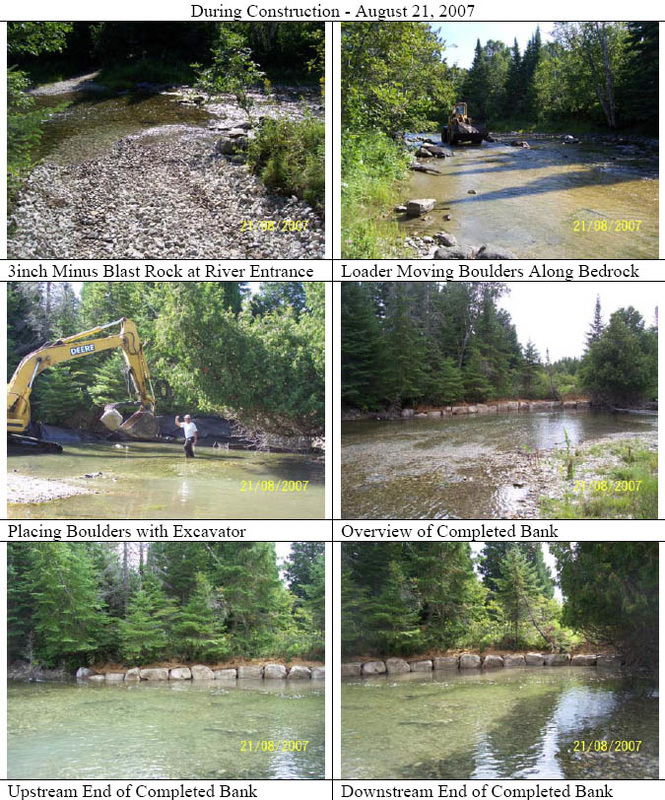
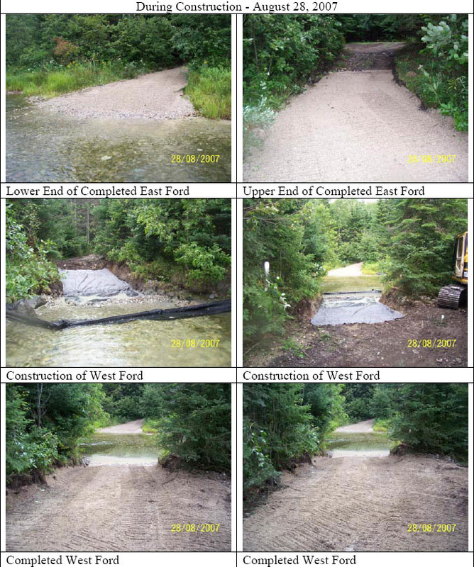
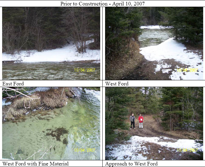
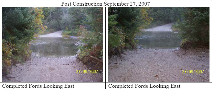
The rehabilitation of Manitou River Site M-03 involved the enhancement of fish habitat adjacent to an existing ford and the stabilization of the ford to prevent further sedimentation from occurring. This access is utilized by many recreational landowners who cross the Manitou River to reach their properties on the other side. Movement across this ford caused silt and clay to continually erode downstream and cover locally important spawning habitat (i.e. gravel). This site was in drastic need of fish habitat protection, improvement and rehabilitation. The placement of clean and smooth ½” average diameter, glacial origin spawning gravel to a depth of 0.3 m was placed over an area of 200 m2 immediately downstream of the ford. As well, large 20-30 cm boulders were placed to prevent the downstream migration of the placed spawning gravel and it also provides current breaks and habitat for juvenile fish and aquatic invertebrates to use. The work was completed according to the site plans through the cooperation of landowners, dedication of “Manitoulin Streams” volunteers, consulting expertise of Great Lakes Environmental Services (GLES) and equipment, material, and services of Lloyd & Sons Trucking Ltd. Funds from various sources were used to complete this project. Heavy equipment rental and purchase of materials to complete the project were paid for by the following funds; CFWIP, Eco-Action and COA contributed for site supervision by a certified engineer. This project had up to 19 volunteers from Manitoulin Streams working on this project at various times.
Manitoulin Streams had numerous meetings and email communications to discuss the details about this project including sending out Site Design Request for Proposals, Tenders and Site Supervision to ensure proper delivery of site design and issuing a winner of the bids. A total of 50 hours of volunteered hours was dedicated by “Manitoulin Streams” committee members attending meetings to discuss planning procedures. Overseas communication (by phone and email) with the landowners had to take place in order to rehabilitate this site. Also, meetings with employees of the Royal Michael’s Bay Resort on behalf of the landowners to gain access to the property for site rehabilitation occurred. CFWIP money was used to purchase non-woven geo-textile and installation of a 300mm layer of compacting Granular “A” gravel material and field stone. This fall, salmon were seen spawning in this newly placed spawning gravel.
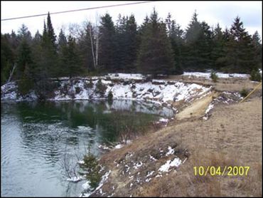
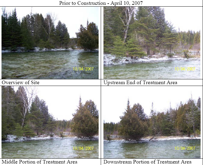
Erosion of the stream bank had caused sediment to be displaced down stream over critical fish habitat. The pictures demonstrate the erosion occurring at the point of entry and exit of the Manitou River which needs bank stabilization. Meetings with Royal Michael’s Bay Resort took place to discuss rehabilitation efforts.
The rehabilitation of Manitou River Site M-03 involved the enhancement of fish habitat adjacent to an existing ford and the stabilization of the ford to prevent further sedimentation from occurring. This access is utilized by many recreational landowners who cross the Manitou River to reach their properties on the other side. Movement across this ford caused silt and clay to continually erode downstream and cover locally important spawning habitat (i.e. gravel). This site was in drastic need of fish habitat protection, improvement and rehabilitation. The placement of clean and smooth ½” average diameter, glacial origin spawning gravel to a depth of 0.3 m was placed over an area of 200 m2 immediately downstream of the ford. As well, large 20-30 cm boulders were placed to prevent the downstream migration of the placed spawning gravel and it also provides current breaks and habitat for juvenile fish and aquatic invertebrates to use. The work was completed according to the site plans through the cooperation of landowners, dedication of “Manitoulin Streams” volunteers, consulting expertise of Great Lakes Environmental Services (GLES) and equipment, material, and services of Lloyd & Sons Trucking Ltd. Funds from various sources were used to complete this project. Heavy equipment rental and purchase of materials to complete the project were paid for by the following funds; CFWIP, Eco-Action and COA contributed for site supervision by a certified engineer. This project had up to 19 volunteers from Manitoulin Streams working on this project at various times.
Manitoulin Streams had numerous meetings and email communications to discuss the details about this project including sending out Site Design Request for Proposals, Tenders and Site Supervision to ensure proper delivery of site design and issuing a winner of the bids. A total of 50 hours of volunteered hours was dedicated by “Manitoulin Streams” committee members attending meetings to discuss planning procedures. Overseas communication (by phone and email) with the landowners had to take place in order to rehabilitate this site. Also, meetings with employees of the Royal Michael’s Bay Resort on behalf of the landowners to gain access to the property for site rehabilitation occurred. CFWIP money was used to purchase non-woven geo-textile and installation of a 300mm layer of compacting Granular “A” gravel material and field stone. This fall, salmon were seen spawning in this newly placed spawning gravel.
Erosion of the stream bank had caused sediment to be displaced down stream over critical fish habitat. The pictures demonstrate the erosion occurring at the point of entry and exit of the Manitou River which needs bank stabilization. Meetings with Royal Michael’s Bay Resort took place to discuss rehabilitation efforts.
Site M29
Bank Stabilization Project
The work was generally completed according to the plans. Due to the high bank and fine sand substrate present, the contractor suggested adding clay soil material on top of the newly 2:1 sloped sand bank to help retain moisture (and encourage the rapid re-growth of vegetation) in the overlying topsoil. This was discussed with a Manitoulin Streams representative and it was agreed that the additional clay material (15 tandem loads) would be applied.
Site M-29 is located where the Manitou River meanders to the east and from consequence of a lack of riparian vegetation, the western bank has undergone extensive erosion as a result of historic poor land use practices. The area affected totals 70 meters in length is composed primarily of loose fine sands. This area was growing in size with each flood event.
There was a pressing need to complete restoration plans for site M-29 as the site’s proximity to Government Road makes it ideal to serve as a demonstration site for the “Manitoulin Streams” initiative. Documented outside stream bank erosion cutting into the unprotected bank was creating slumped banks. The significant erosion was subsequently infilling downstream pools and other critical aquatic habitats with sediment and thus reducing the total available critical fish habitat features in the river. Therefore, excessive erosion at this site warranted the need to mitigate this situation through the; installation of large boulders at the toe of where the slope met the waters edge to dissipate the power of high water flows; sloping the river bank to a more stabile 2:1 ratio and planting and re-establishing a dense riparian vegetation zone. When combined, these two restoration initiatives will further increase bank stability while simultaneously providing shade and a cooling effect for the adjacent reach of river. Additionally, clean 1 cm diameter glacial origin spawning gravel was placed on the river bottom adjacent to the newly rehabilitated river bank. This enhanced spawning area encompassing an area of approx. 70 m in length by 5 m in width for a total area of 350 m created.
The work involved the installation of ten (10) root wads, (14) boulders, bank grading behind the root wads, topsoil placement, seeding to establish vegetation, the planting of (1,766) shrubs and the placement of spawning gravel 10 x 3m =30m2, 0.3m thick. A section of river bank immediately upstream of the eroded bend was also graded and shrubs and vegetation planted to stabilize the bank and improve fish habitat. This project will contribute to the rehabilitation of the Manitou River and demonstrated the valued benefits of this community stewardship initiative to the general public and other local landowners who are apprehensive about participating. The work was completed according to the site plans through the cooperation of landowners, dedication of volunteers, consulting expertise of Great Lakes Environmental Services (GLES) and equipment, material, and services of C. Pearson & Sons Ltd. The shoreline was stabilized and re-vegetated with eastern white cedar, red maple and spruce trees, speckled alder, red-osier dogwood, and right of way grass mixture. Numerous communications took place by phone as the landowner lived in Southern Ontario. The landowner and her family member made several trips up to Manitoulin Island from Hamilton to meet with the engineer to go over site design and to contribute her in-kind support. Travel took over 16 hours (both ways) x 4 trips, for a total of 64 hrs plus the cost of gas. The landowner contributed to the project by volunteering her time by planting 206 trees. The Lake Manitou Area Association also contributed to planting trees at the site, 10 people/ 3 hrs. This project had up to 19 volunteers from Manitoulin Streams working on this project at various times.
Manitoulin Streams had numerous committee meetings, site inspections, landowner meetings and email communications to discuss the details about this project including sending out Site Design Request for Proposals, Tenders and Site Supervision to ensure proper delivery of site design and issuing a winner of the bids. A total of 80 hours of volunteered hours was dedicated by “Manitoulin Streams” committee members attending meetings to discuss planning procedures. Funds from various sources were used to complete this project; Site Design was paid for by DFO. CFWIP, COA, and Eco-Action were used to pay for heavy equipment rental and materials to complete rehabilitation work. COA also contributed for site supervision by a certified engineer.
Site m42
Bank Stabilization Project
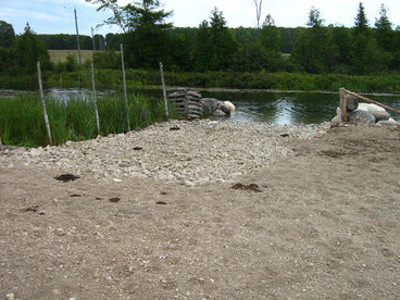
Site M-42 was in need of improved bank stability installing 50 meters of cedar rail fencing that will inhibit livestock access to the river, thus preventing further deterioration of the bank and sedimentation of downstream critical spawning areas and fish habitat. The rehabilitation of Manitou River Site M-42 involved the construction of a livestock watering pad along the bank of the Manitou River. The work involved the removal of the existing, poor quality material and the installation of a new livestock watering pad with a coarse fill topping. Fencing was extended to the edge of the new pad with assistance from the Ontario Stewardship Rangers, volunteers and the landowner to limit livestock access to only the new pad. Large boulders were placed in water to contain both the livestock and the coarse fill used to create the new pad. Poor material surrounding the new pad was removed and replaced with coarse granular fill to help prevent disturbed soil particles from entering the river. The boulders and gravel provide good habitat or cover for juvenile and adult fish and invertebrates since it reaches a 0-3ft depth. Furthermore, the shoreline was stabilized and re-vegetated by the landowner along the inside edge of the fence. Trees will provide shade and cover for fish and wildlife and act as the beginning of the food chain for invertebrates and juvenile fish. The work was completed according to the site plans through the cooperation of the landowner, volunteers, Ontario Stewardship Rangers, consulting expertise of Great Lakes Environmental Services (GLES) and equipment, material, and services of Lloyd & Sons Trucking Ltd. Funds from various sources were used to complete this project; from DFO was for Site Design, CFWIP, and co-Action for rental of heavy equipment and operator and purchase of materials to complete rehabilitation work. COA for Site Supervision by a certified engineer.
This project had 19 volunteers from Manitoulin Streams working on this project at various times. Manitoulin Streams had numerous meetings and email communications to discuss the details about this project including sending out Site Design Request for Proposals (RFP), Tender (RFP) and Site Supervision (RFP) to ensure proper delivery of site design and issuing a winner of the bids. A total of 20 hours of volunteered hours was dedicated by “Manitoulin Streams” committee members attending meetings to discuss planning procedures. CFWIP were used to purchase Armtec 200 non-woven geotextile, 1m diameter boulders and the page wire fencing. CFWIP funds also were used to pay for installation of 600mm thick, 50-100mm nominal size limestone rocks. Eleven Stewardship Rangers volunteered their time to aid the landowner to install the fencing to the watering ramp. It took 16 hours to complete it, therefore 12 people x 16hrs=192 hrs.
site m70
Channel & Bank Rehabilitation Project
Lloyd & Sons Trucking Ltd. was tendered out to supply rock, soil, root wads and geotextile etc. They began work at the site on August 15, 2007 and the majority of the work was completed within 4 working days. The two nose pumps were installed at the site in September 2007. The planting of riparian vegetation was completed the week of October 15, 2007. The work was generally completed according to the plans with one exception as follows. Additional spawning substrate was laid down on the stream bed and a restricted, rock clad secondary cattle ramp was constructed at a point further downstream.
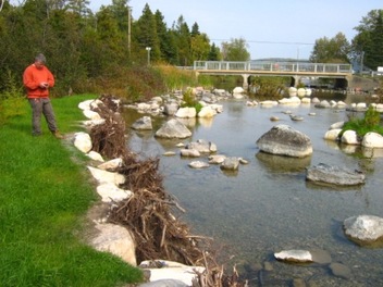
This project’s objective included; rehabilitating the channel centre (70m total width) by reducing the rivers width/depth ratio by narrowing and deepening the channel, improving the aquatic habitat substrate through the extensive addition of spawning sized gravel and larger rock boulders; rehabilitating the channels shorelines by establishing a new shoreline that can withstand the force of peak flood flow conditions while providing fish habitat along its edges; re-establishing the riparian zone and its corresponding vegetation/canopy and installing a fence and remote cattle watering nose pumps to keep livestock from damaging this site again. These actions dramatically improved the aquatic and riparian habitats of this site. This “high visibility” project location which is next to a highly used public park area will contribute to the rehabilitation of the Manitou River and will demonstrate the valued benefits of this community stewardship initiative to the public and other local landowners who are apprehensive about participating.
The rehabilitation of Manitou River Site M-70 involved the installation of three (3) boulder islands, fifteen (15) root wads, one (1) single wing deflector, ten (10) random boulders, two (2) seasonal nose pumps, four (4) sweepers, one (1) boulder weir and the placement of spawning gravel in various areas on the Manitou River just downstream of the Highway 542 Bridge. A riparian area was created and revegetated along the newly established river bank and a fence was built approx. 30m back from the waters edge to restrict any livestock access. All other disturbed areas were revegetated and stabilized by our partner volunteer group, Lake Manitou Area Association. The work was completed according to the site plans through the cooperation of landowners, dedication of volunteers, consulting expertise of Great Lakes Environmental Services (GLES) and equipment, material, and services of Lloyd & Sons Trucking Ltd. Funds from various sources were used to complete this project. DFO contributed for Site Design. Heavy equipment rental and material costs were paid by for the following; CFWIP, COA, and Eco-Action. COA also contributed for Site Supervision by a certified engineer.
This project had 19 volunteers from Manitoulin Streams working on this project at various times. Manitoulin Streams had numerous meetings and email communications to discuss the details about this project including sending out Site Design Request for Proposals (RFP), Tender (RFP) and Site Supervision (RFP) to ensure proper delivery of site design and issuing a winner of the bids. A total of 70 volunteered hours was dedicated by “Manitoulin Streams” committee members attending meetings to discuss planning procedures. An additional 54 volunteer hours were accumulated during numerous meetings with the landowner and the engineer, and planting of (960) trees and shrubs by the Lake Manitou Area Association 10 people x 3 hrs=30hrs. 40m of fencing was installed by 11 Stewardship Rangers and the landowner; 12 people x 4 hours.
Lloyd & Sons Trucking Ltd. was tendered out to supply rock, soil, root wads and geotextile etc. They began work at the site on August 15, 2007 and the majority of the work was completed within 4 working days. The two nose pumps were installed at the site in September 2007. The planting of riparian vegetation was completed the week of October 15, 2007. The work was generally completed according to the plans with one exception as follows. Additional spawning substrate was laid down on the stream bed and a restricted, rock clad secondary cattle ramp was constructed at a point further downstream.
This project’s objective included; rehabilitating the channel centre (70m total width) by reducing the rivers width/depth ratio by narrowing and deepening the channel, improving the aquatic habitat substrate through the extensive addition of spawning sized gravel and larger rock boulders; rehabilitating the channels shorelines by establishing a new shoreline that can withstand the force of peak flood flow conditions while providing fish habitat along its edges; re-establishing the riparian zone and its corresponding vegetation/canopy and installing a fence and remote cattle watering nose pumps to keep livestock from damaging this site again. These actions dramatically improved the aquatic and riparian habitats of this site. This “high visibility” project location which is next to a highly used public park area will contribute to the rehabilitation of the Manitou River and will demonstrate the valued benefits of this community stewardship initiative to the public and other local landowners who are apprehensive about participating.
The rehabilitation of Manitou River Site M-70 involved the installation of three (3) boulder islands, fifteen (15) root wads, one (1) single wing deflector, ten (10) random boulders, two (2) seasonal nose pumps, four (4) sweepers, one (1) boulder weir and the placement of spawning gravel in various areas on the Manitou River just downstream of the Highway 542 Bridge. A riparian area was created and revegetated along the newly established river bank and a fence was built approx. 30m back from the waters edge to restrict any livestock access. All other disturbed areas were revegetated and stabilized by our partner volunteer group, Lake Manitou Area Association. The work was completed according to the site plans through the cooperation of landowners, dedication of volunteers, consulting expertise of Great Lakes Environmental Services (GLES) and equipment, material, and services of Lloyd & Sons Trucking Ltd. Funds from various sources were used to complete this project. DFO contributed for Site Design. Heavy equipment rental and material costs were paid by for the following; CFWIP, COA, and Eco-Action. COA also contributed for Site Supervision by a certified engineer.
This project had 19 volunteers from Manitoulin Streams working on this project at various times. Manitoulin Streams had numerous meetings and email communications to discuss the details about this project including sending out Site Design Request for Proposals (RFP), Tender (RFP) and Site Supervision (RFP) to ensure proper delivery of site design and issuing a winner of the bids. A total of 70 volunteered hours was dedicated by “Manitoulin Streams” committee members attending meetings to discuss planning procedures. An additional 54 volunteer hours were accumulated during numerous meetings with the landowner and the engineer, and planting of (960) trees and shrubs by the Lake Manitou Area Association 10 people x 3 hrs=30hrs. 40m of fencing was installed by 11 Stewardship Rangers and the landowner; 12 people x 4 hours.
