
Mindemoya River - Site MIN-602
Min 602 rehabilitation was about improving the fish habitat (channel edges, channel centre, reducing the width/depth ratio by narrowing and deepening the channel, creating pools, improving available river bottom substrate, and riparian vegetation/canopy) which will reduce the effects of low water levels and increased temperatures in the summer and will enhance the overall quality and productivity of this river’s aquatic and riparian habitats for the long term.
Manitoulin Streams is excited about rehabilitating this site on the Mindemoya River. By providing sustainable fish habitat and structure, Manitoulin Streams hopes to re-establish severely degraded aquatic habitat, which in turn will increase salmonid and other associated species of cold water habitat. Community volunteers were needed to plant riparian and canopy zones as well as contribute to some in-stream habitat creation.
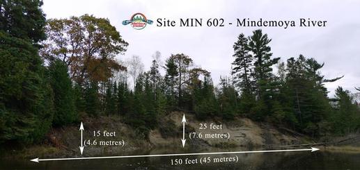
First Nations, OMNR Stewardship Rangers, local landowners, local citizens as well as lake associations and fish and game clubs will all be enlisted to assist in this project. The Mindemoya Enhancement Strategy recommends that rehabilitation of site MIN 602 should include sand bank stabilization and enhancement of in-stream habitat Rehabilitation of site MIN 602 included sand bank stabilization, as well as enhancement of critical in-stream habitat. The sand bank on this site is approximately 46 meters long by 7.5 meters high at its tallest point. This particular site has a large circulating pool which is a critical spawning and nursery area. The culvert at Cranston Road prevents many fish from migrating further upstream. Special consideration was given to create in-stream habitat and the possibility of creating a structure(s) that will allow fish to navigate the step created by the culvert without comprising the road or upstream properties. It should be noted that very low water levels in the fall often compound this navigation issue. The Municipal road may eventually have a bridge installed instead of a culvert, however Municipal representatives indicated a replacement would not be installed in the near future. Heavy equipment was needed for moving materials that will stabilize the sand bank and to create in-stream structures for habitat.
MIN 602 stream restoration involved a variety of stream rehabilitation and bio-engineering techniques including; stabilizing the toe of stream banks with boulders and root wads, creating additional pool and riffle areas, placement of spawning gravel. Proven bio-engineering techniques for riparian zone restoration were implemented to provide fish and wildlife habitat along the river edges. The riparian area will be restored by planting native tree and shrub species such as eastern white cedar, speckled alder, heart leaved willow and native grass seed. This will shade the creek so the water will stay cooler, which will help to maintain an ideal overall water temperature for all cold water biota as well as to provide future suitable shelter and shade for a variety of aquatic and wildlife species.
Manitoulin Streams is excited about rehabilitating this site on the Mindemoya River. By providing sustainable fish habitat and structure, Manitoulin Streams hopes to re-establish severely degraded aquatic habitat, which in turn will increase salmonid and other associated species of cold water habitat. Community volunteers were needed to plant riparian and canopy zones as well as contribute to some in-stream habitat creation.
First Nations, OMNR Stewardship Rangers, local landowners, local citizens as well as lake associations and fish and game clubs will all be enlisted to assist in this project. The Mindemoya Enhancement Strategy recommends that rehabilitation of site MIN 602 should include sand bank stabilization and enhancement of in-stream habitat Rehabilitation of site MIN 602 included sand bank stabilization, as well as enhancement of critical in-stream habitat. The sand bank on this site is approximately 46 meters long by 7.5 meters high at its tallest point. This particular site has a large circulating pool which is a critical spawning and nursery area. The culvert at Cranston Road prevents many fish from migrating further upstream. Special consideration was given to create in-stream habitat and the possibility of creating a structure(s) that will allow fish to navigate the step created by the culvert without comprising the road or upstream properties. It should be noted that very low water levels in the fall often compound this navigation issue. The Municipal road may eventually have a bridge installed instead of a culvert, however Municipal representatives indicated a replacement would not be installed in the near future. Heavy equipment was needed for moving materials that will stabilize the sand bank and to create in-stream structures for habitat.
MIN 602 stream restoration involved a variety of stream rehabilitation and bio-engineering techniques including; stabilizing the toe of stream banks with boulders and root wads, creating additional pool and riffle areas, placement of spawning gravel. Proven bio-engineering techniques for riparian zone restoration were implemented to provide fish and wildlife habitat along the river edges. The riparian area will be restored by planting native tree and shrub species such as eastern white cedar, speckled alder, heart leaved willow and native grass seed. This will shade the creek so the water will stay cooler, which will help to maintain an ideal overall water temperature for all cold water biota as well as to provide future suitable shelter and shade for a variety of aquatic and wildlife species.
