
Mindemoya River - MIN-320b
Bank Restoration and Stabilization
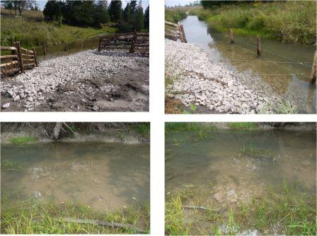
Manitoulin Streams was excited about rehabilitating this final site on the Mindemoya River as it completed our goal of rehabilitating the stretch of the Mindemoya River between Monument Road and Blue Road. The rehabilitation consisted of bank restoration and vegetative bank protection.
Manitoulin Streams restored this severely degraded aquatic & shoreline habitat, which in turn will prevent erosion of soil from its banks reducing sedimentation from occurring over critical spawning habitat and providing sustainable fish habitat and structure to increase productivity of salmonid and other associated cold water species. Improving the fish habitat (channel edges, channel centre, reducing the width/depth ratio by narrowing and deepening the channel, creating pools, improving available river bottom substrate, and riparian vegetation/canopy) in this area will reduce the effects of low water levels and increased temperatures in the summer and will enhance the overall quality and productivity of this river’s aquatic and riparian habitats for the long term.
In addition, we used proven bio-engineering techniques for riparian zone restoration that will provide fish and wildlife habitat along the river edges. The riparian area was restored by planting native tree and shrub species such as eastern speckled alder, red osier dogwood, chokecherry, flowering raspberry, sandbar willow, shining willow, slender willow, elderberry, meadowsweet, nannyberry and native grass seed. This will shade the creek so the water will stay cooler, which will help to maintain an ideal overall water temperature for all cold water biota as well as to provide future suitable shelter and shade for a variety of aquatic and wildlife species.
Total accomplishments include:
This project had 7 volunteers from the Board of Directors of Manitoulin Streams participate in planning and actively volunteering at rehabilitation sites. The total number of hours volunteered for this site is 51.4.
Ontario Rangers had 2 leaders and 7 rangers help out with re-enforcing a shoreline corner bank with clean field stone boulders, cobble/rubble substrate and planting riparian vegetation for a total of 66.5 hours of labour. The 3 landowners contributed 12hrs and equipment.
Ted Ferguson from Ferguson Aggregate donated 2 yards of spawning gravel to create spawning habitat for salmon and trout and installed a French drain to prevent shoreline bank erosion.
Funding contributions toward the construction of the project include CFWIP, COA, Ausauble Bay Conservation Authority, NOHFC, Environment Canada, Turkey Federation and TD Friends of the Environment.
*This project was completed in two sections as it was located within two different properties, click here for direct link to MIN320a!
Manitoulin Streams was excited about rehabilitating this final site on the Mindemoya River as it completed our goal of rehabilitating the stretch of the Mindemoya River between Monument Road and Blue Road. The rehabilitation consisted of bank restoration and vegetative bank protection.
Manitoulin Streams restored this severely degraded aquatic & shoreline habitat, which in turn will prevent erosion of soil from its banks reducing sedimentation from occurring over critical spawning habitat and providing sustainable fish habitat and structure to increase productivity of salmonid and other associated cold water species. Improving the fish habitat (channel edges, channel centre, reducing the width/depth ratio by narrowing and deepening the channel, creating pools, improving available river bottom substrate, and riparian vegetation/canopy) in this area will reduce the effects of low water levels and increased temperatures in the summer and will enhance the overall quality and productivity of this river’s aquatic and riparian habitats for the long term.
In addition, we used proven bio-engineering techniques for riparian zone restoration that will provide fish and wildlife habitat along the river edges. The riparian area was restored by planting native tree and shrub species such as eastern speckled alder, red osier dogwood, chokecherry, flowering raspberry, sandbar willow, shining willow, slender willow, elderberry, meadowsweet, nannyberry and native grass seed. This will shade the creek so the water will stay cooler, which will help to maintain an ideal overall water temperature for all cold water biota as well as to provide future suitable shelter and shade for a variety of aquatic and wildlife species.
Total accomplishments include:
- 474 trees planted
- 37.5 linear (m) of stream buffered and restored
- 4 root wads providing in-stream habitat and bank protection installed
- 1 stone drainage ditch to prevent shoreline bank erosion installed 2.7m x 13m=35.1m2
- 11 linear (m) or (11x3m=33m2) of the shoreline stabilized at a corner bend by hand placing cobble and boulder substrate
- 26.5m x 11.5m =609.5m2 of riparian habitat restored on both sides of the stream
- 0.6095 Hectares of land retired
- (23.5m2) of spawning habitat created
This project had 7 volunteers from the Board of Directors of Manitoulin Streams participate in planning and actively volunteering at rehabilitation sites. The total number of hours volunteered for this site is 51.4.
Ontario Rangers had 2 leaders and 7 rangers help out with re-enforcing a shoreline corner bank with clean field stone boulders, cobble/rubble substrate and planting riparian vegetation for a total of 66.5 hours of labour. The 3 landowners contributed 12hrs and equipment.
Ted Ferguson from Ferguson Aggregate donated 2 yards of spawning gravel to create spawning habitat for salmon and trout and installed a French drain to prevent shoreline bank erosion.
Funding contributions toward the construction of the project include CFWIP, COA, Ausauble Bay Conservation Authority, NOHFC, Environment Canada, Turkey Federation and TD Friends of the Environment.
*This project was completed in two sections as it was located within two different properties, click here for direct link to MIN320a!
