Manitoulin Streams
  • Home
  • About
    • Why Restore Streams?
    • Board Members
    • AGM
    • Staff
  • Donate & Support
    • Memberships >
      • OFAH/MS Membership
      • Friends of Manitoulin Streams Membership
    • Donations >
      • Gift Catalogue
      • In Memory of Donation
      • Store
      • Tree Sales
    • Events >
      • Father's Day Local Gourmet Food Box
      • Jacket & Jeans
    • Volunteer
  • Stream Restoration
    • Strategic Planning
    • Environmental Farm Plan
    • Virtual Stream Tours
    • Awards
    • Stream Locations
    • 2021 >
      • Smith Bay Creek; Wiikwemkoong
    • 2020 >
      • M'Chigeeng Creek
      • Grimesthorpe Creek
      • Bass Lake Creek
      • Manitou River M26
    • 2019 >
      • Grimesthorpe S17, S18, S19
      • Manitou M17.3
      • Shrigley Creek
      • M'Chigeeng Creek
    • 2018 >
      • Kagawong KAG172, KAG174
      • M'Chigeeng Creek
      • Wiky Smith Bay Creek
    • 2017 >
      • Grimesthorpe S16
      • Mindemoya River MIN 662-664
      • Kagawong KAG160, KAG169, KAG170
      • M'Chigeeng Creek
      • Wiky - Smith Bay Creek
    • 2016 >
      • Mindemoya Site 680
      • Mindemoya Site 624
      • Mindemoya Site 620
      • Mindemoya Site 622
      • M'Chigeeng Creek
      • Manitou River Site M13
    • 2015 >
      • Kagawong River - KAG-160
      • Kagawong River - KAG-169
      • Kagawong River - KAG-170
      • M'Chigeeng Creek
      • Grimesthorpe Creek - GS-15
    • 2014 >
      • M'Chigeeng Creek
      • Bass Lake Creek
      • Mindemoya River - MIN-678
      • Mindemoya River - MIN-902 Viewing Platform Construction
      • James Creek
    • 2013 >
      • Bickell's Creek
      • Mindemoya River - MIN-602
      • Mindemoya River - MIN-604
      • Mindemoya River - MIN-900 & MIN-902
    • 2012 >
      • Green Bay Creek
      • Grimesthorpe Creek
      • Lower Norton's Creek
      • Mindemoya River - MIN-320a
      • Mindemoya River - MIN-320b
    • 2011 >
      • Manitou River - M-38
      • Lower Norton's Creek
      • Grimesthorpe Creek
      • Mindemoya River - MIN-308 & MIN-310
      • Mindemoya River - MIN-614
    • 2010 >
      • Bass Lake Creek
      • Mill Creek
      • Manitou River - M-64
      • Manitou River - M-65
      • Mindemoya River - MIN-302, MIN-304, MIN-306
    • 2009 >
      • Blue Jay Creek - B50-B53 Phase II
      • Manitou River - M-35
      • Manitou River - M-48
      • Manitou River - M-63
      • Nortons Creek Phase II
    • 2008 >
      • Blue Jay Creek - B50-B53 Phase I
      • Manitou River - M-70a, M70c
      • Bass Lake Creek
      • Nortons Creek Phase I
    • 2003 - 2007 >
      • 2003
      • 2005 >
        • Manitou River - M-37
        • Manitou River - M-48 to M-52
      • 2006 >
        • Manitou River - M-06
        • Manitou River - M-47
        • Manitou River - M-50
        • Manitou River - M-51
        • Manitou River - M-52
      • 2007 >
        • Manitou River - M-02
        • Manitou River - M-03
        • Manitou River - M-29
        • Manitou River - M-42
        • Manitou River - M-70
  • Boat Launches Manitoulin Island
    • Eastern
    • Western
    • Middle
  • Educating the Public
    • Species at Risk >
      • Northern Map Turtle
      • The Bald Eagle
      • Bobolink
      • Black Tern
      • Barn Swallow
      • Northern Brook Lamprey
      • Short Jaw Cisco
      • Short Nose Cisco
      • Upper Great Lakes Kiyi
      • Cerulean Warbler
      • Eastern Meadowlark
      • Henslow's Sparrow
      • Least Bittern
      • Loggerhead Shrike
      • Peregrine Falcon
      • Piping Plover
      • Yellow Rail
      • Lake Sturgeon
      • Dwarf Lake Iris
      • Aweme Borer Moth
      • Gattinger"s Agalinis
      • Hill's Pondweed
      • Houghton's Goldenrod
      • Lakeside Daisy
      • Pitcher's Thistle
      • Eastern Ribbon Snake
      • Massasauga Rattle Snake
      • Blanding's Turtle
      • Snapping Turtle
      • Bank Swallow
    • Youth Interactive Fun >
      • Colouring pages; printable
      • What is a watershed
    • Climate Change >
      • Fisheries
      • Human Health
      • Agriculture
    • Invasive Species Awareness >
      • Giant Hogweed
      • Phragmites Australis (Common Reed)
      • Wild Parsnip
      • Round Goby
      • Sea Lamprey
      • Rusty Crayfish
      • Emerald Ash Borer
      • What can you do!
      • GIS
    • Hunter & Trapper Workshops >
      • Importance of Hunting & Trapping
    • School Tours
  • Stewardship Initiatives
    • Deer Save >
      • Property Access Permission Form
    • Fish Hatcheries & Aquaculture
    • Invasive Species Management
    • Jack Lighting
    • MASC News Archive >
      • 2014
      • 2013
      • 2012
  • Tours
    • Customize Your Own Streams Experience
    • Stream Detective
    • Wilderness Awareness Session by the Stream
    • Yoga Session by the Stream
    • Nature Walk; Eco Guided Tour
    • Kayaking Sessions
    • Nature Meditation by the Stream
    • Native Art Sessions
    • Horseback Riding Experience
    • Snowshoeing Adventure in Providence Bay
    • Learn to Fish Experience
  • Media
    • News Archive >
      • 2021
      • 2020
      • 2019
      • 2018
      • 2017
      • 2016
      • 2015
      • 2014
      • 2012
      • 2013
      • 2011
      • 2010
      • 2009
      • 2008
      • 2007
      • 2006
      • 2005
      • 2004
      • 1999
    • Newsletters >
      • 2021
      • 2020
      • 2019
      • 2018
      • 2017
      • 2016
      • 2015
      • 2014
      • 2013
      • 2012
      • 2011
      • 2010
      • 2009
    • Photo Archive >
      • 2021
      • 2020
      • 2019
      • 2018
      • 2017
      • 2016
      • 2015
      • 2014
      • 2013
      • 2012
    • Video Archive >
      • 2021
      • 2020
      • 2019
      • 2018
      • 2017
    • Video; Norton's Creek Brook Trout Egg Release
  • Get Involved
    • Suggested Reading
    • Fun Stuff
  • Funding & Partners
    • Corporate, School, and Clubs
    • Provincial and Federal
    • Municipal
    • Local Sponsors and Supporters
  • Links
  • Contact

Manitou River – Site M-06

Picture
Channel Rehabilitation Project

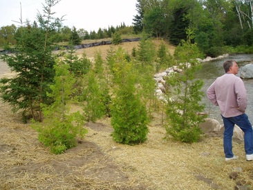
This community driven project was set out to improve the ecological diversity and productivity of the Manitou River.  The work was completed according to the site plans through the cooperation of landowners, dedicated of volunteers, consulting expertise of Great Lakes Environmental Services (GLES) and equipment, material, and services of Lloyd & Sons Trucking Ltd.   This project worked to create a stream channel that is narrower and deeper than the existing channel which subsequently increased the available resting, foraging and juvenile rearing habitat for the valued recreational sport fish of the Manitou River (i.e. Chinook salmon, Coho salmon and Steelhead).  The undertaking involved, purchasing and installing 100 cubic meters of 600 mm boulders to mitigate shoreline erosion, the drilling of boulders to secure “root wad” fish habitat structures and planting native vegetation to establish a riparian buffer zone.  Funds from COA and CFWIP were put towards purchasing materials for the rehabilitation of this site. Aquatic restoration work completed included the installation and strategic placement of 600mm boulders to channelize flow and prevent further scouring of the riverbank which subsequently leads to sedimentation of the riverbed. This project was completed by restoring the riparian vegetation, which included the planting of eastern white cedar and white clover.

Home
​About
Stream Restoration
Contact
"A true conservationist is a man who knows that the world is not given by his fathers, but borrowed from his children."
-John James Audubon
© COPYRIGHT 2015. ALL RIGHTS RESERVED.