Manitoulin Streams
  • Home
  • About
    • Why Restore Streams?
    • Board Members
    • AGM
    • Staff
  • Donate & Support
    • Memberships >
      • OFAH/MS Membership
      • Friends of Manitoulin Streams Membership
    • Donations >
      • Gift Catalogue
      • In Memory of Donation
      • Store
      • Tree Sales
    • Events >
      • Father's Day Local Gourmet Food Box
      • Jacket & Jeans
    • Volunteer
  • Stream Restoration
    • Strategic Planning
    • Environmental Farm Plan
    • Virtual Stream Tours
    • Awards
    • Stream Locations
    • 2021 >
      • Smith Bay Creek; Wiikwemkoong
    • 2020 >
      • M'Chigeeng Creek
      • Grimesthorpe Creek
      • Bass Lake Creek
      • Manitou River M26
    • 2019 >
      • Grimesthorpe S17, S18, S19
      • Manitou M17.3
      • Shrigley Creek
      • M'Chigeeng Creek
    • 2018 >
      • Kagawong KAG172, KAG174
      • M'Chigeeng Creek
      • Wiky Smith Bay Creek
    • 2017 >
      • Grimesthorpe S16
      • Mindemoya River MIN 662-664
      • Kagawong KAG160, KAG169, KAG170
      • M'Chigeeng Creek
      • Wiky - Smith Bay Creek
    • 2016 >
      • Mindemoya Site 680
      • Mindemoya Site 624
      • Mindemoya Site 620
      • Mindemoya Site 622
      • M'Chigeeng Creek
      • Manitou River Site M13
    • 2015 >
      • Kagawong River - KAG-160
      • Kagawong River - KAG-169
      • Kagawong River - KAG-170
      • M'Chigeeng Creek
      • Grimesthorpe Creek - GS-15
    • 2014 >
      • M'Chigeeng Creek
      • Bass Lake Creek
      • Mindemoya River - MIN-678
      • Mindemoya River - MIN-902 Viewing Platform Construction
      • James Creek
    • 2013 >
      • Bickell's Creek
      • Mindemoya River - MIN-602
      • Mindemoya River - MIN-604
      • Mindemoya River - MIN-900 & MIN-902
    • 2012 >
      • Green Bay Creek
      • Grimesthorpe Creek
      • Lower Norton's Creek
      • Mindemoya River - MIN-320a
      • Mindemoya River - MIN-320b
    • 2011 >
      • Manitou River - M-38
      • Lower Norton's Creek
      • Grimesthorpe Creek
      • Mindemoya River - MIN-308 & MIN-310
      • Mindemoya River - MIN-614
    • 2010 >
      • Bass Lake Creek
      • Mill Creek
      • Manitou River - M-64
      • Manitou River - M-65
      • Mindemoya River - MIN-302, MIN-304, MIN-306
    • 2009 >
      • Blue Jay Creek - B50-B53 Phase II
      • Manitou River - M-35
      • Manitou River - M-48
      • Manitou River - M-63
      • Nortons Creek Phase II
    • 2008 >
      • Blue Jay Creek - B50-B53 Phase I
      • Manitou River - M-70a, M70c
      • Bass Lake Creek
      • Nortons Creek Phase I
    • 2003 - 2007 >
      • 2003
      • 2005 >
        • Manitou River - M-37
        • Manitou River - M-48 to M-52
      • 2006 >
        • Manitou River - M-06
        • Manitou River - M-47
        • Manitou River - M-50
        • Manitou River - M-51
        • Manitou River - M-52
      • 2007 >
        • Manitou River - M-02
        • Manitou River - M-03
        • Manitou River - M-29
        • Manitou River - M-42
        • Manitou River - M-70
  • Boat Launches Manitoulin Island
    • Eastern
    • Western
    • Middle
  • Educating the Public
    • Species at Risk >
      • Northern Map Turtle
      • The Bald Eagle
      • Bobolink
      • Black Tern
      • Barn Swallow
      • Northern Brook Lamprey
      • Short Jaw Cisco
      • Short Nose Cisco
      • Upper Great Lakes Kiyi
      • Cerulean Warbler
      • Eastern Meadowlark
      • Henslow's Sparrow
      • Least Bittern
      • Loggerhead Shrike
      • Peregrine Falcon
      • Piping Plover
      • Yellow Rail
      • Lake Sturgeon
      • Dwarf Lake Iris
      • Aweme Borer Moth
      • Gattinger"s Agalinis
      • Hill's Pondweed
      • Houghton's Goldenrod
      • Lakeside Daisy
      • Pitcher's Thistle
      • Eastern Ribbon Snake
      • Massasauga Rattle Snake
      • Blanding's Turtle
      • Snapping Turtle
      • Bank Swallow
    • Youth Interactive Fun >
      • Colouring pages; printable
      • What is a watershed
    • Climate Change >
      • Fisheries
      • Human Health
      • Agriculture
    • Invasive Species Awareness >
      • Giant Hogweed
      • Phragmites Australis (Common Reed)
      • Wild Parsnip
      • Round Goby
      • Sea Lamprey
      • Rusty Crayfish
      • Emerald Ash Borer
      • What can you do!
      • GIS
    • Hunter & Trapper Workshops >
      • Importance of Hunting & Trapping
    • School Tours
  • Stewardship Initiatives
    • Deer Save >
      • Property Access Permission Form
    • Fish Hatcheries & Aquaculture
    • Invasive Species Management
    • Jack Lighting
    • MASC News Archive >
      • 2014
      • 2013
      • 2012
  • Tours
    • Customize Your Own Streams Experience
    • Stream Detective
    • Wilderness Awareness Session by the Stream
    • Yoga Session by the Stream
    • Nature Walk; Eco Guided Tour
    • Kayaking Sessions
    • Nature Meditation by the Stream
    • Native Art Sessions
    • Horseback Riding Experience
    • Snowshoeing Adventure in Providence Bay
    • Learn to Fish Experience
  • Media
    • News Archive >
      • 2021
      • 2020
      • 2019
      • 2018
      • 2017
      • 2016
      • 2015
      • 2014
      • 2012
      • 2013
      • 2011
      • 2010
      • 2009
      • 2008
      • 2007
      • 2006
      • 2005
      • 2004
      • 1999
    • Newsletters >
      • 2021
      • 2020
      • 2019
      • 2018
      • 2017
      • 2016
      • 2015
      • 2014
      • 2013
      • 2012
      • 2011
      • 2010
      • 2009
    • Photo Archive >
      • 2021
      • 2020
      • 2019
      • 2018
      • 2017
      • 2016
      • 2015
      • 2014
      • 2013
      • 2012
    • Video Archive >
      • 2021
      • 2020
      • 2019
      • 2018
      • 2017
    • Video; Norton's Creek Brook Trout Egg Release
  • Get Involved
    • Suggested Reading
    • Fun Stuff
  • Funding & Partners
    • Corporate, School, and Clubs
    • Provincial and Federal
    • Municipal
    • Local Sponsors and Supporters
  • Links
  • Contact

Grimesthorpe Creek - GS-15

Picture
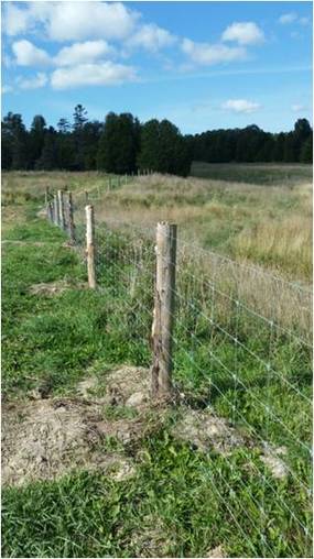
This year's sites included a section of Grimesthorpe Creek, designated as S-15, located in Spring Bay.  The site had been diagnosed as a Medium Priority site, with a lack of riparian buffer zone around the stream, problems with bank stability and also the presence of livestock.  The decided upon solution was to install fencing around the section of stream which would restrict the livestock access, while providing a livestock ramp in one location for watering access.  Within the fenced off area riparian habitat was enhanced with planting of various kinds of trees.  The Sudbury District Stewardship Rangers came down to lend a helping hand in planting, together with 5 of the Streams staff​​, over 500 trees.  Additionally the landowner provided in-kind support in the form of boulders, watering of trees and attending project meetings.  In total, 14 volunteers participated on this restoration effort for a grand total of 170 volunteered hours.  All in all a definite success!

Total accomplishments include:
•276 trees planted through TD Friends of the Environment
•251 trees provided by MASC
•6841m2 of riparian habitat enhanced and protected
• 275 linear meters of stream or 1020m2 of in-stream protected
• 1 boulder cluster installed
•  282 linear meters of page wire fencing installed to restrict livestock from eroding the shoreline and defecating in stream
• 1 livestock ramp installed to provide one location for a water source.

Home
​About
Stream Restoration
Contact
"A true conservationist is a man who knows that the world is not given by his fathers, but borrowed from his children."
-John James Audubon
© COPYRIGHT 2015. ALL RIGHTS RESERVED.