
Bickell's Creek
Rehabilitation and Enhancement Project
Bickel’s creek is a 5.6km tributary of Lake Huron and is a well known rainbow trout and salmon spawning area. With drier summers and less precipitation this creek is becoming less navigable for fish to reach these critical spawning habitats.
The objective of this stream restoration plan will is to work with the United Fish and Game Club and Gore Bay Fish and Game Club to improve 0.4km of the tributary by creating vortex weirs near the mouth in the vicinity of the confluence with the bay to prevent sediment and sand build up, improving the vertical access up the tributary by narrowing and creating weeping weirs to deepen water levels, construction of fish habitat structures (placing spawning gravel and random boulders, weeping weirs and woody material, etc.) and planting native trees and shrubs to create shade, reduce water temperatures and to provide protection from predators. Native trees and shrubs species including white cedar, willow, red osier dogwood, Balsam Fir, American Highbush Cranberry, American Elderberry etc. were planted along the creek. This will help keep the water cooler, which will help to maintain an ideal overall water temperature for all cold water biota as well as provide future suitable shelter and shade for a variety of aquatic and wildlife species.
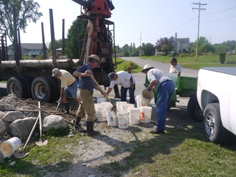
Furthermore, plant root systems will allow for natural stabilization of the creek banks to prevent further erosion and sediment deposits onto spawning ground and other aquatic habitat. Community volunteers (First Nations, OMNR Ontario Rangers, local landowners, Gore Bay Fish and Game Club, the United Fish and Game Club, local citizens) were called on to help with riparian vegetation planting and installing in-stream habitat (weeping weirs, vortex weirs, spawning gravel, woody material etc.). Stream restoration at Bickel’s Creek will increase the reproductive potential for spawning Chinook and Coho salmon in the fall and Rainbow trout in the spring. This project demonstrates the valued benefits of this community stewardship initiative, increasing angling opportunities and creating economic spin-offs.
Bickel’s creek is a 5.6km tributary of Lake Huron and is a well known rainbow trout and salmon spawning area. With drier summers and less precipitation this creek is becoming less navigable for fish to reach these critical spawning habitats.
The objective of this stream restoration plan will is to work with the United Fish and Game Club and Gore Bay Fish and Game Club to improve 0.4km of the tributary by creating vortex weirs near the mouth in the vicinity of the confluence with the bay to prevent sediment and sand build up, improving the vertical access up the tributary by narrowing and creating weeping weirs to deepen water levels, construction of fish habitat structures (placing spawning gravel and random boulders, weeping weirs and woody material, etc.) and planting native trees and shrubs to create shade, reduce water temperatures and to provide protection from predators. Native trees and shrubs species including white cedar, willow, red osier dogwood, Balsam Fir, American Highbush Cranberry, American Elderberry etc. were planted along the creek. This will help keep the water cooler, which will help to maintain an ideal overall water temperature for all cold water biota as well as provide future suitable shelter and shade for a variety of aquatic and wildlife species.
Furthermore, plant root systems will allow for natural stabilization of the creek banks to prevent further erosion and sediment deposits onto spawning ground and other aquatic habitat. Community volunteers (First Nations, OMNR Ontario Rangers, local landowners, Gore Bay Fish and Game Club, the United Fish and Game Club, local citizens) were called on to help with riparian vegetation planting and installing in-stream habitat (weeping weirs, vortex weirs, spawning gravel, woody material etc.). Stream restoration at Bickel’s Creek will increase the reproductive potential for spawning Chinook and Coho salmon in the fall and Rainbow trout in the spring. This project demonstrates the valued benefits of this community stewardship initiative, increasing angling opportunities and creating economic spin-offs.

In partenership with TD Friends of the Environment Foundation
