Manitoulin Streams
  • Home
  • About
    • Why Restore Streams?
    • Board Members
    • AGM
    • Staff
  • Donate & Support
    • Memberships >
      • OFAH/MS Membership
      • Friends of Manitoulin Streams Membership
    • Donations >
      • Gift Catalogue
      • In Memory of Donation
      • Store
      • Tree Sales
    • Events >
      • Father's Day Local Gourmet Food Box
      • Jacket & Jeans
    • Volunteer
  • Stream Restoration
    • Strategic Planning
    • Environmental Farm Plan
    • Virtual Stream Tours
    • Awards
    • Stream Locations
    • 2021 >
      • Smith Bay Creek; Wiikwemkoong
    • 2020 >
      • M'Chigeeng Creek
      • Grimesthorpe Creek
      • Bass Lake Creek
      • Manitou River M26
    • 2019 >
      • Grimesthorpe S17, S18, S19
      • Manitou M17.3
      • Shrigley Creek
      • M'Chigeeng Creek
    • 2018 >
      • Kagawong KAG172, KAG174
      • M'Chigeeng Creek
      • Wiky Smith Bay Creek
    • 2017 >
      • Grimesthorpe S16
      • Mindemoya River MIN 662-664
      • Kagawong KAG160, KAG169, KAG170
      • M'Chigeeng Creek
      • Wiky - Smith Bay Creek
    • 2016 >
      • Mindemoya Site 680
      • Mindemoya Site 624
      • Mindemoya Site 620
      • Mindemoya Site 622
      • M'Chigeeng Creek
      • Manitou River Site M13
    • 2015 >
      • Kagawong River - KAG-160
      • Kagawong River - KAG-169
      • Kagawong River - KAG-170
      • M'Chigeeng Creek
      • Grimesthorpe Creek - GS-15
    • 2014 >
      • M'Chigeeng Creek
      • Bass Lake Creek
      • Mindemoya River - MIN-678
      • Mindemoya River - MIN-902 Viewing Platform Construction
      • James Creek
    • 2013 >
      • Bickell's Creek
      • Mindemoya River - MIN-602
      • Mindemoya River - MIN-604
      • Mindemoya River - MIN-900 & MIN-902
    • 2012 >
      • Green Bay Creek
      • Grimesthorpe Creek
      • Lower Norton's Creek
      • Mindemoya River - MIN-320a
      • Mindemoya River - MIN-320b
    • 2011 >
      • Manitou River - M-38
      • Lower Norton's Creek
      • Grimesthorpe Creek
      • Mindemoya River - MIN-308 & MIN-310
      • Mindemoya River - MIN-614
    • 2010 >
      • Bass Lake Creek
      • Mill Creek
      • Manitou River - M-64
      • Manitou River - M-65
      • Mindemoya River - MIN-302, MIN-304, MIN-306
    • 2009 >
      • Blue Jay Creek - B50-B53 Phase II
      • Manitou River - M-35
      • Manitou River - M-48
      • Manitou River - M-63
      • Nortons Creek Phase II
    • 2008 >
      • Blue Jay Creek - B50-B53 Phase I
      • Manitou River - M-70a, M70c
      • Bass Lake Creek
      • Nortons Creek Phase I
    • 2003 - 2007 >
      • 2003
      • 2005 >
        • Manitou River - M-37
        • Manitou River - M-48 to M-52
      • 2006 >
        • Manitou River - M-06
        • Manitou River - M-47
        • Manitou River - M-50
        • Manitou River - M-51
        • Manitou River - M-52
      • 2007 >
        • Manitou River - M-02
        • Manitou River - M-03
        • Manitou River - M-29
        • Manitou River - M-42
        • Manitou River - M-70
  • Boat Launches Manitoulin Island
    • Eastern
    • Western
    • Middle
  • Educating the Public
    • Species at Risk >
      • Northern Map Turtle
      • The Bald Eagle
      • Bobolink
      • Black Tern
      • Barn Swallow
      • Northern Brook Lamprey
      • Short Jaw Cisco
      • Short Nose Cisco
      • Upper Great Lakes Kiyi
      • Cerulean Warbler
      • Eastern Meadowlark
      • Henslow's Sparrow
      • Least Bittern
      • Loggerhead Shrike
      • Peregrine Falcon
      • Piping Plover
      • Yellow Rail
      • Lake Sturgeon
      • Dwarf Lake Iris
      • Aweme Borer Moth
      • Gattinger"s Agalinis
      • Hill's Pondweed
      • Houghton's Goldenrod
      • Lakeside Daisy
      • Pitcher's Thistle
      • Eastern Ribbon Snake
      • Massasauga Rattle Snake
      • Blanding's Turtle
      • Snapping Turtle
      • Bank Swallow
    • Youth Interactive Fun >
      • Colouring pages; printable
      • What is a watershed
    • Climate Change >
      • Fisheries
      • Human Health
      • Agriculture
    • Invasive Species Awareness >
      • Giant Hogweed
      • Phragmites Australis (Common Reed)
      • Wild Parsnip
      • Round Goby
      • Sea Lamprey
      • Rusty Crayfish
      • Emerald Ash Borer
      • What can you do!
      • GIS
    • Hunter & Trapper Workshops >
      • Importance of Hunting & Trapping
    • School Tours
  • Stewardship Initiatives
    • Deer Save >
      • Property Access Permission Form
    • Fish Hatcheries & Aquaculture
    • Invasive Species Management
    • Jack Lighting
    • MASC News Archive >
      • 2014
      • 2013
      • 2012
  • Tours
    • Customize Your Own Streams Experience
    • Stream Detective
    • Wilderness Awareness Session by the Stream
    • Yoga Session by the Stream
    • Nature Walk; Eco Guided Tour
    • Kayaking Sessions
    • Nature Meditation by the Stream
    • Native Art Sessions
    • Horseback Riding Experience
    • Snowshoeing Adventure in Providence Bay
    • Learn to Fish Experience
  • Media
    • News Archive >
      • 2021
      • 2020
      • 2019
      • 2018
      • 2017
      • 2016
      • 2015
      • 2014
      • 2012
      • 2013
      • 2011
      • 2010
      • 2009
      • 2008
      • 2007
      • 2006
      • 2005
      • 2004
      • 1999
    • Newsletters >
      • 2021
      • 2020
      • 2019
      • 2018
      • 2017
      • 2016
      • 2015
      • 2014
      • 2013
      • 2012
      • 2011
      • 2010
      • 2009
    • Photo Archive >
      • 2021
      • 2020
      • 2019
      • 2018
      • 2017
      • 2016
      • 2015
      • 2014
      • 2013
      • 2012
    • Video Archive >
      • 2021
      • 2020
      • 2019
      • 2018
      • 2017
    • Video; Norton's Creek Brook Trout Egg Release
  • Get Involved
    • Suggested Reading
    • Fun Stuff
  • Funding & Partners
    • Corporate, School, and Clubs
    • Provincial and Federal
    • Municipal
    • Local Sponsors and Supporters
  • Links
  • Contact

Bass Lake Creek 

Picture
Spawning Habitat Enhancement Project

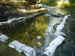
The 2010 Bass Lake Creek spawning habitat enhancement project site is traditionally a very active spawning area specifically for Walleye, Salmon and Trout.  Due to fluctuating water levels coming out of Bass Lake the area in which the fish would spawn would be underwater during the spawning period, but the level of water would drop and leave this valuable and popular spawning area dry, causing a high mortality rate in the spawned eggs.

In order to rehabilitate or enhance this site, a plan was created to chisel and excavate a 5m x 7m (approx. 16’ x 24’) area of shale Lindsay formation to a depth of 1.3 metres below its current level and fill the bottom 30 cm with spawning gravel. The total surface area of enhanced productive spawning area produced was 35m2. The project brought the river bed in this area flush with the rest of the river bed, which allowed this popular spawning area to be underwater year round.  Also, conducted at this site was bank stabilization where another 7m x 4m or 28m2 was repaired, graded and planted with Right of Way mixture grass seed.

Funding contributions toward the construction of the project include CFWIP, COA and NOHFC.

This project had 3 volunteers from the Little Current Fish and Game Club, 2 volunteers worked a combined 10 hours on preparation work at the site consisting mostly of delivery and washing of spawning gravel.  The landowner provided 18.5 hours of site supervision and preliminary site visits with contractors for the project.

This project also had 7 volunteers from the Board of Directors of Manitoulin Streams participate in planning and actively volunteering at rehabilitation sites. The total number of hours volunteered for this site is 51.4 hours.


Home
​About
Stream Restoration
Contact
"A true conservationist is a man who knows that the world is not given by his fathers, but borrowed from his children."
-John James Audubon
© COPYRIGHT 2015. ALL RIGHTS RESERVED.