Manitoulin Streams
  • Home
  • About
    • Why Restore Streams?
    • Board Members
    • AGM
    • Staff
  • Donate & Support
    • Memberships >
      • OFAH/MS Membership
      • Friends of Manitoulin Streams Membership
    • Donations >
      • Gift Catalogue
      • In Memory of Donation
      • Store
      • Tree Sales
    • Events >
      • Jacket & Jeans
    • Volunteer
  • GOURMET FOOD BOX
    • Order Form
  • Stream Restoration
    • Strategic Planning
    • Environmental Farm Plan
    • Virtual Stream Tours
    • Awards
    • Stream Locations
    • 2020 >
      • M'Chigeeng Creek
      • Grimesthorpe Creek
      • Bass Lake Creek
      • Manitou River M26
    • 2019 >
      • Grimesthorpe S17, S18, S19
      • Manitou M17.3
      • Shrigley Creek
      • M'Chigeeng Creek
    • 2018 >
      • Kagawong KAG172, KAG174
      • M'Chigeeng Creek
      • Wiky Smith Bay Creek
    • 2017 >
      • Grimesthorpe S16
      • Mindemoya River MIN 662-664
      • Kagawong KAG160, KAG169, KAG170
      • M'Chigeeng Creek
      • Wiky - Smith Bay Creek
    • 2016 >
      • Mindemoya Site 680
      • Mindemoya Site 624
      • Mindemoya Site 620
      • Mindemoya Site 622
      • M'Chigeeng Creek
      • Manitou River Site M13
    • 2015 >
      • Kagawong River - KAG-160
      • Kagawong River - KAG-169
      • Kagawong River - KAG-170
      • M'Chigeeng Creek
      • Grimesthorpe Creek - GS-15
    • 2014 >
      • M'Chigeeng Creek
      • Bass Lake Creek
      • Mindemoya River - MIN-678
      • Mindemoya River - MIN-902 Viewing Platform Construction
      • James Creek
    • 2013 >
      • Bickell's Creek
      • Mindemoya River - MIN-602
      • Mindemoya River - MIN-604
      • Mindemoya River - MIN-900 & MIN-902
    • 2012 >
      • Green Bay Creek
      • Grimesthorpe Creek
      • Lower Norton's Creek
      • Mindemoya River - MIN-320a
      • Mindemoya River - MIN-320b
    • 2011 >
      • Manitou River - M-38
      • Lower Norton's Creek
      • Grimesthorpe Creek
      • Mindemoya River - MIN-308 & MIN-310
      • Mindemoya River - MIN-614
    • 2010 >
      • Bass Lake Creek
      • Mill Creek
      • Manitou River - M-64
      • Manitou River - M-65
      • Mindemoya River - MIN-302, MIN-304, MIN-306
    • 2009 >
      • Blue Jay Creek - B50-B53 Phase II
      • Manitou River - M-35
      • Manitou River - M-48
      • Manitou River - M-63
      • Nortons Creek Phase II
    • 2008 >
      • Blue Jay Creek - B50-B53 Phase I
      • Manitou River - M-70a, M70c
      • Bass Lake Creek
      • Nortons Creek Phase I
    • 2003 - 2007 >
      • 2003
      • 2005 >
        • Manitou River - M-37
        • Manitou River - M-48 to M-52
      • 2006 >
        • Manitou River - M-06
        • Manitou River - M-47
        • Manitou River - M-50
        • Manitou River - M-51
        • Manitou River - M-52
      • 2007 >
        • Manitou River - M-02
        • Manitou River - M-03
        • Manitou River - M-29
        • Manitou River - M-42
        • Manitou River - M-70
  • Educating the Public
    • Species at Risk >
      • Northern Map Turtle
      • The Bald Eagle
      • Bobolink
      • Black Tern
      • Barn Swallow
      • Northern Brook Lamprey
      • Short Jaw Cisco
      • Short Nose Cisco
      • Upper Great Lakes Kiyi
      • Cerulean Warbler
      • Eastern Meadowlark
      • Henslow's Sparrow
      • Least Bittern
      • Loggerhead Shrike
      • Peregrine Falcon
      • Piping Plover
      • Yellow Rail
      • Lake Sturgeon
      • Dwarf Lake Iris
      • Aweme Borer Moth
      • Gattinger"s Agalinis
      • Hill's Pondweed
      • Houghton's Goldenrod
      • Lakeside Daisy
      • Pitcher's Thistle
      • Eastern Ribbon Snake
      • Massasauga Rattle Snake
      • Blanding's Turtle
      • Snapping Turtle
      • Bank Swallow
    • Youth Interactive Fun >
      • Colouring pages; printable
      • What is a watershed
    • Climate Change >
      • Fisheries
      • Human Health
      • Agriculture
    • Invasive Species Awareness >
      • Giant Hogweed
      • Phragmites Australis (Common Reed)
      • Wild Parsnip
      • Round Goby
      • Sea Lamprey
      • Rusty Crayfish
      • Emerald Ash Borer
      • What can you do!
      • GIS
    • Hunter & Trapper Workshops >
      • Importance of Hunting & Trapping
    • School Tours
  • Stewardship Initiatives
    • Deer Save >
      • Property Access Permission Form
    • Fish Hatcheries & Aquaculture
    • Invasive Species Management
    • Jack Lighting
    • MASC News Archive >
      • 2014
      • 2013
      • 2012
  • Tours
    • Customize Your Own Streams Experience
    • Stream Detective
    • Wilderness Awareness Session by the Stream
    • Yoga Session by the Stream
    • Nature Walk; Eco Guided Tour
    • Kayaking Sessions
    • Nature Meditation by the Stream
    • Native Art Sessions
    • Horseback Riding Experience
    • Snowshoeing Adventure in Providence Bay
    • Learn to Fish Experience
  • Media
    • News Archive >
      • 2020
      • 2019
      • 2018
      • 2017
      • 2016
      • 2015
      • 2014
      • 2012
      • 2013
      • 2011
      • 2010
      • 2009
      • 2008
      • 2007
      • 2006
      • 2005
      • 2004
      • 1999
    • Newsletters >
      • 2020
      • 2019
      • 2018
      • 2017
      • 2016
      • 2015
      • 2014
      • 2013
      • 2012
      • 2011
      • 2010
      • 2009
    • Photo Archive >
      • 2020
      • 2019
      • 2018
      • 2017
      • 2016
      • 2015
      • 2014
      • 2013
      • 2012
    • Video Archive >
      • 2020
      • 2019
      • 2018
      • 2017
    • Video; Norton's Creek Brook Trout Egg Release
  • Get Involved
    • Suggested Reading
    • Fun Stuff
  • Funding & Partners
    • Corporate, School, and Clubs
    • Provincial and Federal
    • Municipal
    • Local Sponsors and Supporters
  • Links
  • Contact
back

Roundy Goby
Neogobius melanostomus

Picture
The round goby is a small, bottom-dwelling invasive fish. Native to the Black and Caspian seas in eastern Europe, it was first found in North America in 1990 in the St. Clair River north of Windsor, Ontario. Researchers believe the fish was brought to North America in the ballast water of ships from Europe. In less than a decade the round goby has successfully spread through all five Great Lakes and has begun to invade inland waters. In some areas the fish has reached densities of more than 100 fish per square metre.

The round goby prefer waters with rocky and sandy bottoms. They feed aggressively on insects and other small organisms found on lake and river bottoms. The adult round goby eats large quantities of zebra and quagga mussels, as well as small fish and fish eggs. Their aggressive eating habits and ability to spawn several times each season have helped them multiply and spread quickly.

Range

Outside its native range, the round goby has been found in all five Great Lakes and many of their tributaries, including the Illinois River. Round goby are also found in some inland waters in southern Ontario such as Lake Simcoe, the Trent River, Rice Lake, and parts of the Otonabee River. 

Click here for the Early Detection & Distribution Mapping System (EDDMapS) to view and contribute to Round Goby sightings in Ontario.

Impacts of Round Goby

The round goby's aggressive habits and rapid spread have had serious impacts on native species.
  • The fish compete with and prey on native bottom-dwelling fish such as mottled sculpin (Cottus bairdii) and logperch (Percina caprodes). Round goby also threaten several species at risk in the Great Lakes Basin, including the northern madtom (Noturus stigmosus), the eastern sand darter (Ammocrypta pellucida), and several species of freshwater mussels.
  • Round goby have reduced populations of sport fish by eating their eggs and young and competing for food sources.
  • Researchers believe the round goby is linked to outbreaks of botulism type E in Great Lakes fish and fish-eating birds. The disease is caused by a toxin that may be passed from zebra mussels, to goby, to birds, resulting in large die-offs of fish and birds.
To prevent the spread of this invasive species, the Ontario government has banned the possession of live round goby and the use of round goby as a baitfish.

How to Identify Round Goby

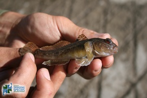
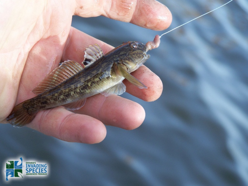
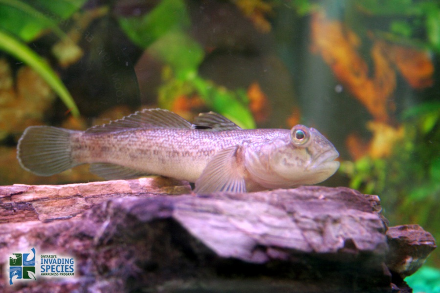
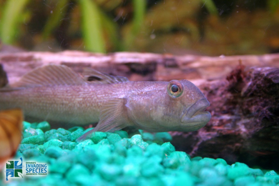
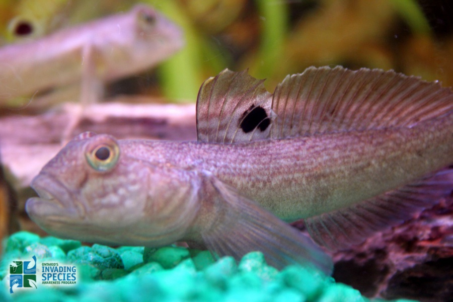
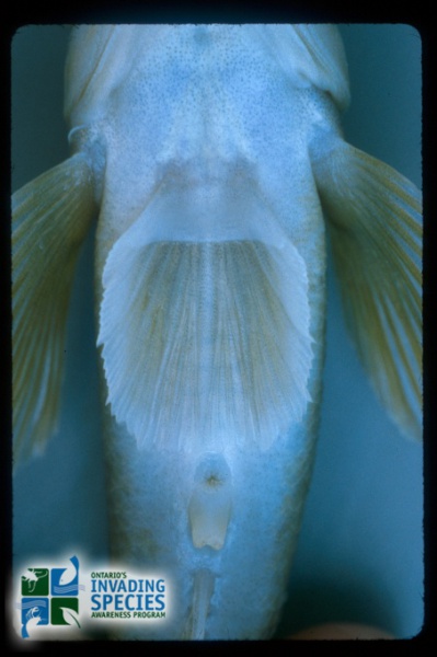
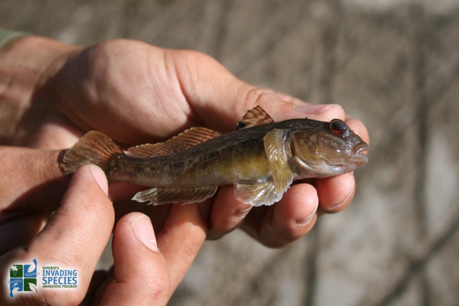
Adult round goby are six to 16 centimetres long with a cylindrical body and a rounded to blunt snout. The round goby looks similar to several species of fish found in the Great Lakes, including the invasive tubenose goby (Myoxocephalus thompsoni) and native sculpins (Cottus sp.).

What You Can Do

  • Learn how to identify round goby and how to prevent the spread of this unwanted species.
  • Never buy or use round goby as bait. It is against the law to use round goby as bait or to have a live round goby in your possession.
  • Don’t put any live fish into Ontario lakes, rivers or streams.
  • If you have any information about the illegal importing, distribution or sale of round goby, report it immediately to the MNR TIPS line at 1-877-TIPS-MNR (847-7667) toll-free any time, or contact your local MNR office during regular business hours. You can also call Crime Stoppers anonymously at 1-800-222-TIPS (8477).
  • If you’ve seen a round goby or other invasive species in the wild, please contact the toll-free Invading Species Hotline at 1-800-563-7711, or report a sighting online.
OFAH/OMNR Invading Species Awareness Program. (2012). Round Goby. Retrieved from:http://www.invadingspecies.com. This factsheet may be reproduced for non-commercial purposes.
Home
​About
Stream Restoration
Contact
"A true conservationist is a man who knows that the world is not given by his fathers, but borrowed from his children."
-John James Audubon
© COPYRIGHT 2015. ALL RIGHTS RESERVED.