Manitoulin Streams
  • Home
  • About
    • Why Restore Streams?
    • Board Members
    • AGM
    • Staff
  • Donate & Support
    • Memberships >
      • OFAH/MS Membership
      • Friends of Manitoulin Streams Membership
    • Donations >
      • Gift Catalogue
      • In Memory of Donation
      • Store
      • Tree Sales
    • Events >
      • Jacket & Jeans
    • Volunteer
  • Stream Restoration
    • Strategic Planning
    • Environmental Farm Plan
    • Virtual Stream Tours
    • Awards
    • Stream Locations
    • 2020 >
      • M'Chigeeng Creek
      • Grimesthorpe Creek
      • Bass Lake Creek
      • Manitou River M26
    • 2019 >
      • Grimesthorpe S17, S18, S19
      • Manitou M17.3
      • Shrigley Creek
      • M'Chigeeng Creek
    • 2018 >
      • Kagawong KAG172, KAG174
      • M'Chigeeng Creek
      • Wiky Smith Bay Creek
    • 2017 >
      • Grimesthorpe S16
      • Mindemoya River MIN 662-664
      • Kagawong KAG160, KAG169, KAG170
      • M'Chigeeng Creek
      • Wiky - Smith Bay Creek
    • 2016 >
      • Mindemoya Site 680
      • Mindemoya Site 624
      • Mindemoya Site 620
      • Mindemoya Site 622
      • M'Chigeeng Creek
      • Manitou River Site M13
    • 2015 >
      • Kagawong River - KAG-160
      • Kagawong River - KAG-169
      • Kagawong River - KAG-170
      • M'Chigeeng Creek
      • Grimesthorpe Creek - GS-15
    • 2014 >
      • M'Chigeeng Creek
      • Bass Lake Creek
      • Mindemoya River - MIN-678
      • Mindemoya River - MIN-902 Viewing Platform Construction
      • James Creek
    • 2013 >
      • Bickell's Creek
      • Mindemoya River - MIN-602
      • Mindemoya River - MIN-604
      • Mindemoya River - MIN-900 & MIN-902
    • 2012 >
      • Green Bay Creek
      • Grimesthorpe Creek
      • Lower Norton's Creek
      • Mindemoya River - MIN-320a
      • Mindemoya River - MIN-320b
    • 2011 >
      • Manitou River - M-38
      • Lower Norton's Creek
      • Grimesthorpe Creek
      • Mindemoya River - MIN-308 & MIN-310
      • Mindemoya River - MIN-614
    • 2010 >
      • Bass Lake Creek
      • Mill Creek
      • Manitou River - M-64
      • Manitou River - M-65
      • Mindemoya River - MIN-302, MIN-304, MIN-306
    • 2009 >
      • Blue Jay Creek - B50-B53 Phase II
      • Manitou River - M-35
      • Manitou River - M-48
      • Manitou River - M-63
      • Nortons Creek Phase II
    • 2008 >
      • Blue Jay Creek - B50-B53 Phase I
      • Manitou River - M-70a, M70c
      • Bass Lake Creek
      • Nortons Creek Phase I
    • 2003 - 2007 >
      • 2003
      • 2005 >
        • Manitou River - M-37
        • Manitou River - M-48 to M-52
      • 2006 >
        • Manitou River - M-06
        • Manitou River - M-47
        • Manitou River - M-50
        • Manitou River - M-51
        • Manitou River - M-52
      • 2007 >
        • Manitou River - M-02
        • Manitou River - M-03
        • Manitou River - M-29
        • Manitou River - M-42
        • Manitou River - M-70
  • Educating the Public
    • Species at Risk >
      • Northern Map Turtle
      • The Bald Eagle
      • Bobolink
      • Black Tern
      • Barn Swallow
      • Northern Brook Lamprey
      • Short Jaw Cisco
      • Short Nose Cisco
      • Upper Great Lakes Kiyi
      • Cerulean Warbler
      • Eastern Meadowlark
      • Henslow's Sparrow
      • Least Bittern
      • Loggerhead Shrike
      • Peregrine Falcon
      • Piping Plover
      • Yellow Rail
      • Lake Sturgeon
      • Dwarf Lake Iris
      • Aweme Borer Moth
      • Gattinger"s Agalinis
      • Hill's Pondweed
      • Houghton's Goldenrod
      • Lakeside Daisy
      • Pitcher's Thistle
      • Eastern Ribbon Snake
      • Massasauga Rattle Snake
      • Blanding's Turtle
      • Snapping Turtle
      • Bank Swallow
    • Youth Interactive Fun >
      • Colouring pages; printable
      • What is a watershed
    • Climate Change >
      • Fisheries
      • Human Health
      • Agriculture
    • Invasive Species Awareness >
      • Giant Hogweed
      • Phragmites Australis (Common Reed)
      • Wild Parsnip
      • Round Goby
      • Sea Lamprey
      • Rusty Crayfish
      • Emerald Ash Borer
      • What can you do!
      • GIS
    • Hunter & Trapper Workshops >
      • Importance of Hunting & Trapping
    • School Tours
  • Stewardship Initiatives
    • Deer Save >
      • Property Access Permission Form
    • Fish Hatcheries & Aquaculture
    • Invasive Species Management
    • Jack Lighting
    • MASC News Archive >
      • 2014
      • 2013
      • 2012
  • Tours
    • Customize Your Own Streams Experience
    • Stream Detective
    • Wilderness Awareness Session by the Stream
    • Yoga Session by the Stream
    • Nature Walk; Eco Guided Tour
    • Kayaking Sessions
    • Nature Meditation by the Stream
    • Native Art Sessions
    • Horseback Riding Experience
    • Snowshoeing Adventure in Providence Bay
    • Learn to Fish Experience
  • Media
    • News Archive >
      • 2020
      • 2019
      • 2018
      • 2017
      • 2016
      • 2015
      • 2014
      • 2012
      • 2013
      • 2011
      • 2010
      • 2009
      • 2008
      • 2007
      • 2006
      • 2005
      • 2004
      • 1999
    • Newsletters >
      • 2020
      • 2019
      • 2018
      • 2017
      • 2016
      • 2015
      • 2014
      • 2013
      • 2012
      • 2011
      • 2010
      • 2009
    • Photo Archive >
      • 2020
      • 2019
      • 2018
      • 2017
      • 2016
      • 2015
      • 2014
      • 2013
      • 2012
    • Video Archive >
      • 2020
      • 2019
      • 2018
      • 2017
    • Video; Norton's Creek Brook Trout Egg Release
  • Get Involved
    • Suggested Reading
    • Fun Stuff
  • Funding & Partners
    • Corporate, School, and Clubs
    • Provincial and Federal
    • Municipal
    • Local Sponsors and Supporters
  • Links
  • Contact
Back

Invasive Phragmites
Phragmites australis subsp. australis

Picture
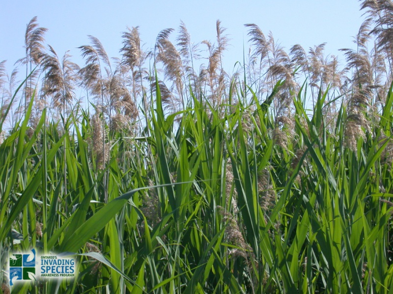
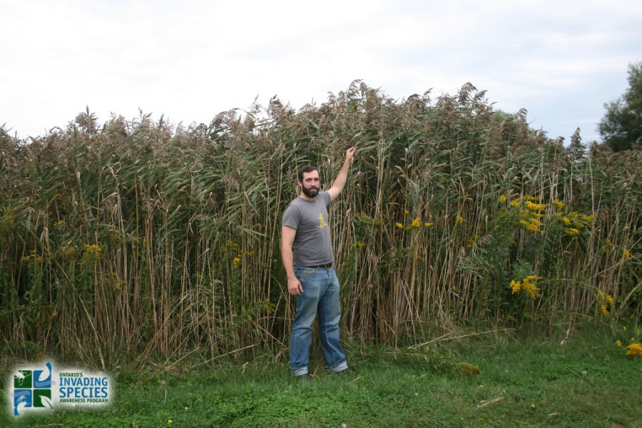
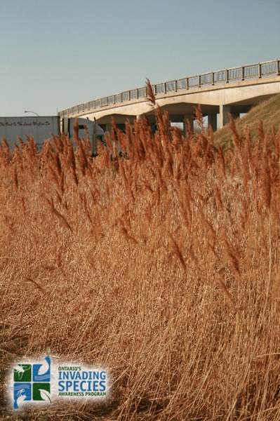
Invasive Phragmites is an aggressive plant that spreads quickly and out-competes native species for water and nutrients. It releases acid from its roots into the soil to hinder the growth of and kill surrounding plants. While it prefers areas of standing water, its roots can grow to extreme lengths, allowing it to survive in relatively dry areas.

Invasive Phragmites (European Common Reed) is a perennial grass that has been causing damage to Ontario's biodiversity, wetlands and beaches for decades It is not clear how it was transported to North America from it's native home in Eurasia but it is believed to have been brought here to be used in gardening and landscaping.  

Impacts of Invasive Phragmites

  • crowds out native vegetation, thus resulting in decreased plant biodiversity;
  • provides poor habitat and food supplies for wildlife
  • destroys habitat and food supplies that wildlife depends on, including several Species at Risk;
  • grows very quickly thereby causing lower water levels as water is transpired faster than it would be with native vegetation;
  • increases fire hazards as stands are composed of a high percentage of dead stalks; and
  • can affect agriculture, cause road safety hazard and impact recreational activities such as swimming, boating and angling.

Range

 Click here for the Early Detection & Distribution Mapping System (EDDMapS) to view and contribute to Phragmites sightings in Ontario.

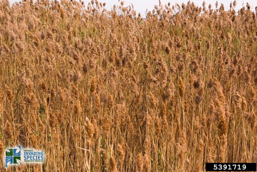
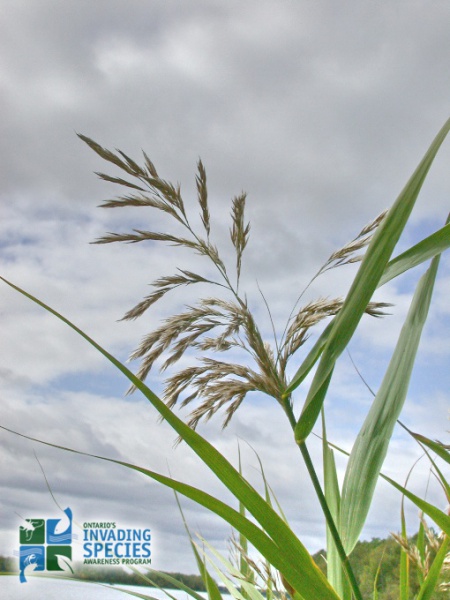
Identifying Invasive Phragmites

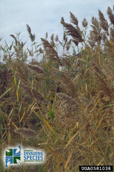
One factor making the identification of invasive Phragmites difficult is the existence of a closely related native subspecies. Generally, native Phragmites does not grow as tall as the invasive plant and does not out-compete other native species.  Several characteristics of the plant can be useful in distinguishing between the native variety and invasive Phragmites. The following information can help in identifying invasive Phragmites.
Invasive Phragmites:
  • grows in stands that can be extremely dense with as many as 200 stems per square metre;
  • can grow so densely that it crowds out other species;
  • can reach heights of up to 5 metres (15 feet), and
  • has stems that are tan or beige in colour with blue-green leaves and large, dense seedheads.
Native Phragmites:
  • grows in stands that are usually not as dense as the invasive plant;
  • well-established stands are frequently mixed with other plants; and
  • usually has more reddish-brown stems, yellow-green leaves and smaller, sparser seedheads.

What You Can Do

  • Learn how to identify invasive Phragmites and how to avoid accidentally spreading it through its root fragments and seeds. This is especially important if you are planning to do work in an area which contains invasive Phragmites.
  • Do not plant invasive Phragmites. Native Phragmites have the same appearance and do not pose an ecological risk.
  • Gardeners should use only native or non-invasive plants and are encouraged to ask garden centres for plants that are not invasive.
  • Stay on designated trails. Leaving trails or entering areas containing invasive Phragmites can encourage the spread of this plant. When leaving an area containing invasive Phragmites, brush off clothing and clean equipment onsite to avoid the transfer of seeds to new areas. Remove all visible portions of plants and dispose them in the garbage.
  • Do not compost invasive Phragmites. Both seeds and rhizomes (horizontal plant stems growing underground) can survive and grow in compost.
  • If you find invasive phragmites or other invasive species in the wild, please contact the Invading Species Hotline at 1-800-563-7711, or report a sighting online.

Downloads

Phragmites Field Guide
File Size: 2766 kb
File Type: pdf
Download File

Phragmites Info Sheet
File Size: 3932 kb
File Type: pdf
Download File

Phragmites Fact Sheet
File Size: 307 kb
File Type: pdf
Download File

OFAH/OMNR Invading Species Awareness Program. (2012). Invasive Phragmites. Retrieved from:http://www.invadingspecies.com. This factsheet may be reproduced for non-commercial purposes.
Home
​About
Stream Restoration
Contact
"A true conservationist is a man who knows that the world is not given by his fathers, but borrowed from his children."
-John James Audubon
© COPYRIGHT 2015. ALL RIGHTS RESERVED.