Manitoulin Streams
  • Home
  • About
    • Why Restore Streams?
    • Board Members
    • AGM
    • Staff
  • Donate & Support
    • Memberships >
      • OFAH/MS Membership
      • Friends of Manitoulin Streams Membership
    • Donations >
      • Gift Catalogue
      • In Memory of Donation
      • Store
      • Tree Sales
    • Events >
      • Jacket & Jeans
    • Volunteer
  • GOURMET FOOD BOX
    • Order Form
  • Stream Restoration
    • Strategic Planning
    • Environmental Farm Plan
    • Virtual Stream Tours
    • Awards
    • Stream Locations
    • 2020 >
      • M'Chigeeng Creek
      • Grimesthorpe Creek
      • Bass Lake Creek
      • Manitou River M26
    • 2019 >
      • Grimesthorpe S17, S18, S19
      • Manitou M17.3
      • Shrigley Creek
      • M'Chigeeng Creek
    • 2018 >
      • Kagawong KAG172, KAG174
      • M'Chigeeng Creek
      • Wiky Smith Bay Creek
    • 2017 >
      • Grimesthorpe S16
      • Mindemoya River MIN 662-664
      • Kagawong KAG160, KAG169, KAG170
      • M'Chigeeng Creek
      • Wiky - Smith Bay Creek
    • 2016 >
      • Mindemoya Site 680
      • Mindemoya Site 624
      • Mindemoya Site 620
      • Mindemoya Site 622
      • M'Chigeeng Creek
      • Manitou River Site M13
    • 2015 >
      • Kagawong River - KAG-160
      • Kagawong River - KAG-169
      • Kagawong River - KAG-170
      • M'Chigeeng Creek
      • Grimesthorpe Creek - GS-15
    • 2014 >
      • M'Chigeeng Creek
      • Bass Lake Creek
      • Mindemoya River - MIN-678
      • Mindemoya River - MIN-902 Viewing Platform Construction
      • James Creek
    • 2013 >
      • Bickell's Creek
      • Mindemoya River - MIN-602
      • Mindemoya River - MIN-604
      • Mindemoya River - MIN-900 & MIN-902
    • 2012 >
      • Green Bay Creek
      • Grimesthorpe Creek
      • Lower Norton's Creek
      • Mindemoya River - MIN-320a
      • Mindemoya River - MIN-320b
    • 2011 >
      • Manitou River - M-38
      • Lower Norton's Creek
      • Grimesthorpe Creek
      • Mindemoya River - MIN-308 & MIN-310
      • Mindemoya River - MIN-614
    • 2010 >
      • Bass Lake Creek
      • Mill Creek
      • Manitou River - M-64
      • Manitou River - M-65
      • Mindemoya River - MIN-302, MIN-304, MIN-306
    • 2009 >
      • Blue Jay Creek - B50-B53 Phase II
      • Manitou River - M-35
      • Manitou River - M-48
      • Manitou River - M-63
      • Nortons Creek Phase II
    • 2008 >
      • Blue Jay Creek - B50-B53 Phase I
      • Manitou River - M-70a, M70c
      • Bass Lake Creek
      • Nortons Creek Phase I
    • 2003 - 2007 >
      • 2003
      • 2005 >
        • Manitou River - M-37
        • Manitou River - M-48 to M-52
      • 2006 >
        • Manitou River - M-06
        • Manitou River - M-47
        • Manitou River - M-50
        • Manitou River - M-51
        • Manitou River - M-52
      • 2007 >
        • Manitou River - M-02
        • Manitou River - M-03
        • Manitou River - M-29
        • Manitou River - M-42
        • Manitou River - M-70
  • Educating the Public
    • Species at Risk >
      • Northern Map Turtle
      • The Bald Eagle
      • Bobolink
      • Black Tern
      • Barn Swallow
      • Northern Brook Lamprey
      • Short Jaw Cisco
      • Short Nose Cisco
      • Upper Great Lakes Kiyi
      • Cerulean Warbler
      • Eastern Meadowlark
      • Henslow's Sparrow
      • Least Bittern
      • Loggerhead Shrike
      • Peregrine Falcon
      • Piping Plover
      • Yellow Rail
      • Lake Sturgeon
      • Dwarf Lake Iris
      • Aweme Borer Moth
      • Gattinger"s Agalinis
      • Hill's Pondweed
      • Houghton's Goldenrod
      • Lakeside Daisy
      • Pitcher's Thistle
      • Eastern Ribbon Snake
      • Massasauga Rattle Snake
      • Blanding's Turtle
      • Snapping Turtle
      • Bank Swallow
    • Youth Interactive Fun >
      • Colouring pages; printable
      • What is a watershed
    • Climate Change >
      • Fisheries
      • Human Health
      • Agriculture
    • Invasive Species Awareness >
      • Giant Hogweed
      • Phragmites Australis (Common Reed)
      • Wild Parsnip
      • Round Goby
      • Sea Lamprey
      • Rusty Crayfish
      • Emerald Ash Borer
      • What can you do!
      • GIS
    • Hunter & Trapper Workshops >
      • Importance of Hunting & Trapping
    • School Tours
  • Stewardship Initiatives
    • Deer Save >
      • Property Access Permission Form
    • Fish Hatcheries & Aquaculture
    • Invasive Species Management
    • Jack Lighting
    • MASC News Archive >
      • 2014
      • 2013
      • 2012
  • Tours
    • Customize Your Own Streams Experience
    • Stream Detective
    • Wilderness Awareness Session by the Stream
    • Yoga Session by the Stream
    • Nature Walk; Eco Guided Tour
    • Kayaking Sessions
    • Nature Meditation by the Stream
    • Native Art Sessions
    • Horseback Riding Experience
    • Snowshoeing Adventure in Providence Bay
    • Learn to Fish Experience
  • Media
    • News Archive >
      • 2020
      • 2019
      • 2018
      • 2017
      • 2016
      • 2015
      • 2014
      • 2012
      • 2013
      • 2011
      • 2010
      • 2009
      • 2008
      • 2007
      • 2006
      • 2005
      • 2004
      • 1999
    • Newsletters >
      • 2020
      • 2019
      • 2018
      • 2017
      • 2016
      • 2015
      • 2014
      • 2013
      • 2012
      • 2011
      • 2010
      • 2009
    • Photo Archive >
      • 2020
      • 2019
      • 2018
      • 2017
      • 2016
      • 2015
      • 2014
      • 2013
      • 2012
    • Video Archive >
      • 2020
      • 2019
      • 2018
      • 2017
    • Video; Norton's Creek Brook Trout Egg Release
  • Get Involved
    • Suggested Reading
    • Fun Stuff
  • Funding & Partners
    • Corporate, School, and Clubs
    • Provincial and Federal
    • Municipal
    • Local Sponsors and Supporters
  • Links
  • Contact

Deer Save 

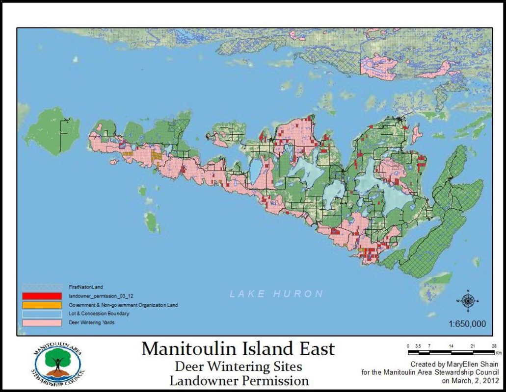
One of the Manitoulin Area Stewardship Council's (MASC) many initiatives before it disbanded as a result of funding cutbacks and dissolved into Manitoulin Streams, was to encourage more extensive community involvement in the sustainable management of this area’s white-tailed deer population.  To endure harsh winter conditions, deer typically migrate from their summer/fall ranges to winter concentration areas, termed as “deer yards”, which have suitable cover and food that will help to sustain them.  These adaptations and good winter habitat enable deer to survive most winters, but under heavy snow conditions it may be necessary to pack-down deer trails and provide emergency feeding.  These actions will help prevent massive die-offs and maintain core deer populations.

To avert this risk, MASC and other Manitoulin organizations have partnered to initiate the “Deer Save” project; to plan and coordinate preparedness for emergency winter deer situations.  Landowners are being contacted if they have property that falls within an important winter deer yard.  MASC is seeking permission to access the deer yards by entering landowner’s properties, should emergency winter conditions arise.  Landowners are being asked to grant MASC permission to their property by signing and returning a landowner permission form and are being provided with a Deer Wintering Fact Sheet to inform them on what they can do to protect and enhance deer habitat.
Picture
deersavewinteringyards.jpg
File Size: 157 kb
File Type: jpg
Download File

Deer Save Documents

new_deer_save_form_2016.doc
File Size: 226 kb
File Type: doc
Download File

Home
​About
Stream Restoration
Contact
"A true conservationist is a man who knows that the world is not given by his fathers, but borrowed from his children."
-John James Audubon
© COPYRIGHT 2015. ALL RIGHTS RESERVED.